



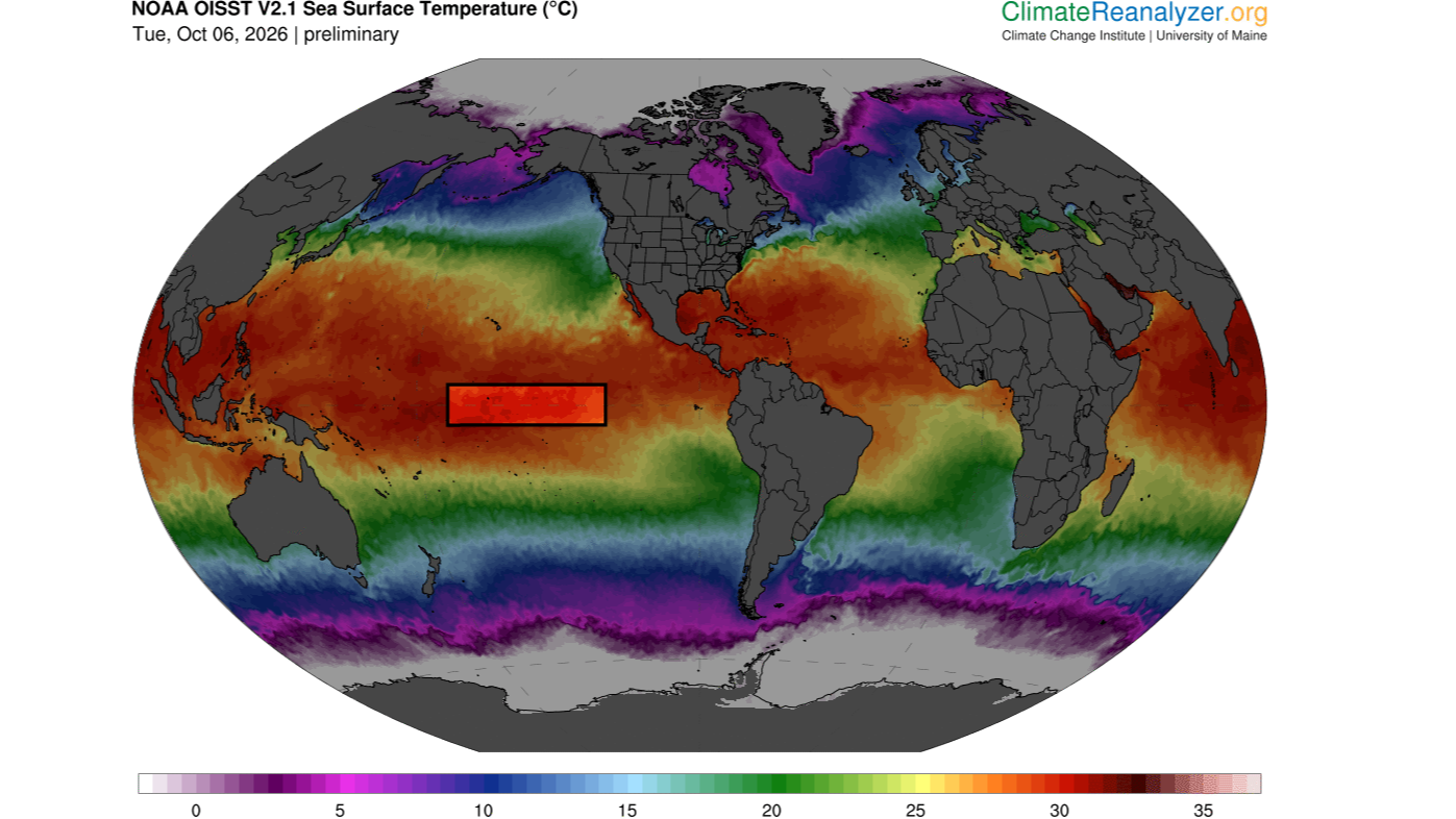

The sea surface temperature in a key section of the central equatorial Pacific Ocean has now surpassed all previous temperatures on record for this region, exceeding 86 degrees Fahrenheit (30 degrees Celsius) for the first time, according to preliminary data released Monday (Oct. 5).
Specifically, these temperatures occurred in the Niño 3.4 region, located between 5 degrees north and 5 degrees south latitude, and 120 degrees west and 170 degrees west longitude. Researchers use this region to monitor the progression of El Niño, the warm phase of a multiyear natural climate pattern that’s currently in full swing and steadily intensifying. But how significant is this new record, and could it be a harbinger of increasingly extreme El Niño events in the future?
At this time of the year, sea surface temperatures above 86 F are common in the western Pacific warm pool, a mass of water located northeast of Australia. But the Niño 3.4 region is nowhere near the warm pool and usually has much cooler temperatures. This latest data indicates “an exceptionally warm state for this part of the tropical Pacific,” said Jin-Yi Yu, a professor of Earth system science at the University of California, Irvine.
“If the reported daily El Niño 3.4 temperature above 30°C is verified in the observational dataset, it would be an extraordinary record,” Yu told Live Science in an email.
Other experts agreed. A Niño 3.4 sea surface temperature above 86 F is a “very significant” new record, Timothy Osborn, a professor of climate science and the director of the Climatic Research Unit at the University of East Anglia in the U.K., told Live Science in an email. Mat Collins, a professor of climate systems and the head of mathematics and statistics at the University of Exeter in the U.K., also called the temperature “very significant” in an email to Live Science.
But it’s important to note that absolute temperature is not the standard way of measuring the strength of El Niño, Osborn said. Researchers usually assess El Niño intensity by comparing sea surface temperatures in the Niño 3.4 region with the average conditions there or with sea surface temperatures across the rest of the tropics, with the latter method removing a skew in the data caused by the climate-change-induced heating of oceans globally.
“On those measures, the current event is already close to being the strongest [El Niño] on record and will likely soon exceed previous records given that the event is forecast to strengthen further,” Osborn said. “For some measures, it is already record-breaking for the time of year.”
Get the world’s most fascinating discoveries delivered straight to your inbox.
“Super” El Niño
El Niño events happen when warm water in the western tropical Pacific Ocean migrates eastward along the equator, toward South America. This boosts global temperatures, triggering heavy rainfall and floods in regions like East Africa, southern China, the southern U.S. and the Pacific coast of equatorial South America, while places such as Indonesia, the Philippines, southern Africa and northern South America experience drought.
“El Nino impacts are greatest across the tropics and in the lands around the Pacific Ocean,” Osborn said. “An El Nino with record strength is very significant because it greatly disrupts the atmospheric circulation which controls the weather patterns including patterns of rainfall.”
As of Oct. 6, the temperature anomaly in the Niño 3.4 region is 6 F (3.34 C) above average and rising. A typical El Niño increases Niño 3.4 temperatures by a maximum of 1.8 to 3.6 F (1 to 2 C) above average, so the current condition is “exceptionally large,” Yu said. “This indicates that a very strong, or what is sometimes called a ‘super,’ El Niño is developing.”
Sea surface temperatures in the Niño 3,4 region exceeded 86 degrees F (30 C) on Oct. 5.
This year’s El Niño is being amplified by human-driven global warming, which has increased background ocean temperatures. As a result, it’s likely that sea surface temperatures in the Niño 3.4 region will keep rising over the coming weeks and peak in November or December, before declining again in 2027, Collins said.
“The Niño 3.4 anomaly is very likely to remain extremely large and may increase further,” Yu said, echoing forecasters’ suggestions that it could reach 7.2 F (4 C) by November.
A new kind of El Niño?
The world is on the brink of crossing a critical warming threshold, raising the question of whether the current conditions can be considered a new normal for future El Niños.
While it’s likely that future El Niños will be more extreme than past ones, on average, not every El Niño will be record-breaking and as dramatic as the one unfolding now, because these events tend to be very variable, Collins said.
As climate change intensifies, the big worry is that certain regions will be primed for extreme conditions even before an El Niño strikes, Osborn said. For example, regions that are getting drier due to global warming could see catastrophic droughts if they overlap with areas that experience dryness during El Niño events. Likewise, places that are getting wetter could see worse deluges of rain and flooding if they coincide with areas with higher precipitation during El Niños. But that doesn’t necessarily mean extreme El Niños are the new normal, he said.
Instead, the location and duration of El Niño events may be transforming, Yu suggested. “In research by my group and collaborators, we have documented changes not only in El Niño intensity, but also in where the warming occurs and how long events persist,” he said.
Yu and his colleagues helped to introduce the idea that we are seeing the emergence of two distinct types of El Niño: the eastern Pacific El Niño and the central Pacific El Niño. “Many El Niño events in the earlier observational record were dominated by warming in the eastern tropical Pacific, whereas Central Pacific El Niño events became much more prominent in recent decades,” he explained, adding that El Niños have also been lasting longer.
Global warming may be creating a new kind of El Niño by strengthening atmosphere-ocean interactions in the subtropical Pacific, Yu said. If these interactions combine with processes in the equatorial Pacific, where eastern Pacific El Niños emerge, they might trigger unusually strong events with extreme heating in the central Pacific.
“That provides a physical reason to take the possibility of more frequent extreme El Niño events in a warmer climate seriously,” Yu said. “But I would distinguish that from saying that every El Niño will become progressively stronger.”