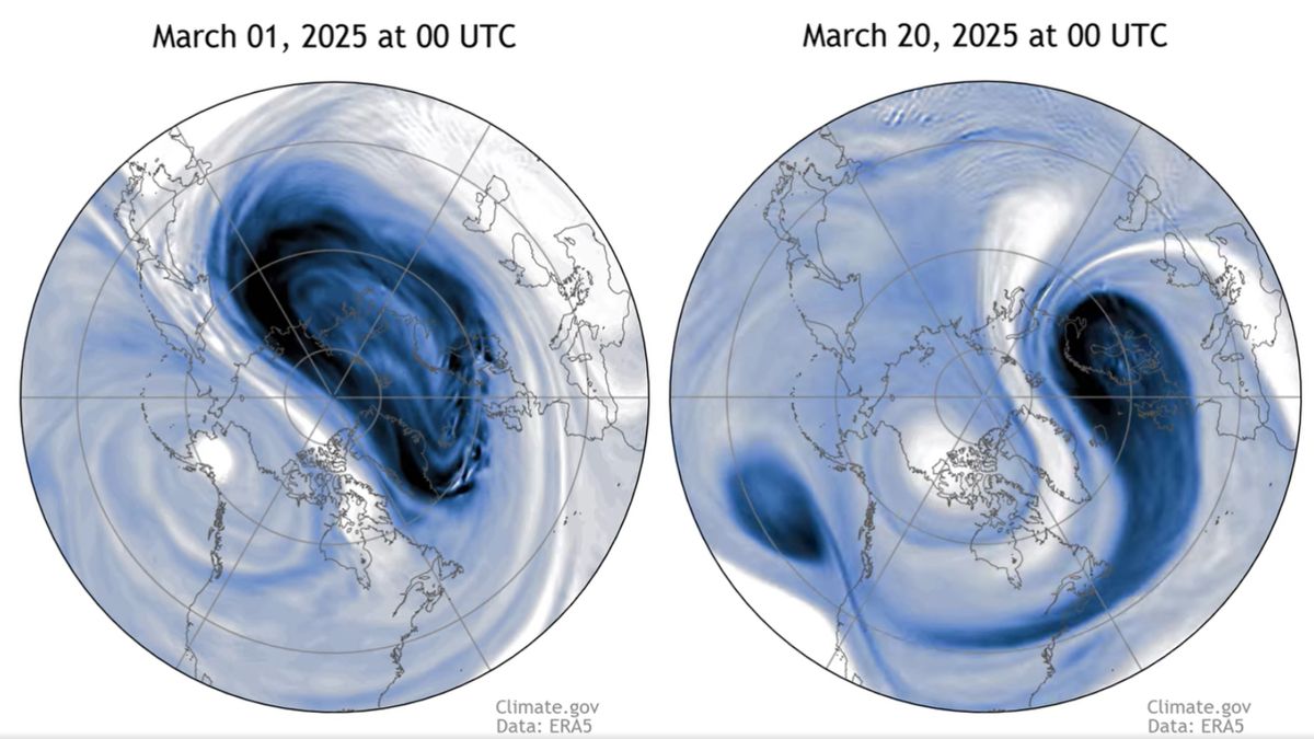
A major disruption to the Arctic polar vortex has bumped the ring of wind that circles the North Pole off its perch and towards Europe, a new animation shows.
The migration could trigger colder-than-average temperatures in parts of the continent and across the eastern U.S. over the coming week, climate scientists say.
The polar vortex started wandering off course March 9, when its high winds suddenly switched from blowing west to east to blowing in the opposite direction. This switch normally happens each year, but it tends to occur in mid-April — meaning this year’s reversal struck unusually early, according to a blog post published April 3 by the National Oceanic and Atmospheric Administration (NOAA).
Watch On
“For much of this winter season, the polar vortex has been strong,” NOAA officials wrote in the blog post. “But like a true atmospheric diva, the polar vortex had one last trick up its sleeve, breaking down in a spectacular fashion and bringing some cold air with it.”
Related: Bizarre polar vortex over Antarctica delayed ozone hole opening, scientists say
The Arctic polar vortex is a circle of strong, cold winds that picks up every winter over the North Pole. The vortex is always present, but it strengthens in the winter due to a redistribution of heat from the tropics. During the winter, the winds that make up the polar vortex blow from west to east. In spring, as Earth’s tilt changes and the North Pole receives more sunlight, the direction of the winds changes to blow from east to west. The winds also become weaker as a result of less heat wafting from the tropics to the pole.
These winds are located in the stratosphere — a layer of the atmosphere that extends between around 6 and 31 miles (10 to 50 kilometers) above Earth’s surface.
Occasional “sudden stratospheric warming” events can disrupt the polar vortex. These events happen when large-scale atmospheric waves, called Rossby waves, get pushed into the stratosphere from below, triggering sudden spikes in temperature. Like ocean waves, Rossby waves can “break” on top of the polar vortex, weakening it and — in extreme cases — reversing the direction of its winds.
Last year, a sudden stratospheric warming event hit the polar vortex and reversed its winds in early March, but the vortex recovered. This time, “the vortex does not seem likely to gain a foothold again,” NOAA officials wrote.
The switch in wind direction doesn’t mean the polar vortex will immediately drop off for the summer, however. The reversed polar vortex has simply “moved off the pole, meandering around over Northern Europe,” officials wrote.
NOAA’s latest forecasts suggest the polar vortex is unlikely to wander back to its normal position over the North Pole. It probably won’t regain its wintertime strength either, officials said, so the likelihood is that it will dissipate and eventually “enter hibernation” over Northern Europe.
As it dissipates, the polar vortex will bring below-average temperatures to Northern Europe, parts of Asia and the eastern U.S., NOAA officials wrote. “Temperatures for the last week of March were pretty normal across the eastern U.S., but the latest forecasts do predict increased chances of below-normal temperatures for the next week,” they wrote.


