


Editor’s note: This is a developing story that will be updated as Hurricane Milton approaches Florida.
Another catastrophic hurricane is barrelling towards Florida’s Gulf Coast just 10 days after Hurricane Helene left at least 230 people dead and thousands of homes flooded across the Southeast.
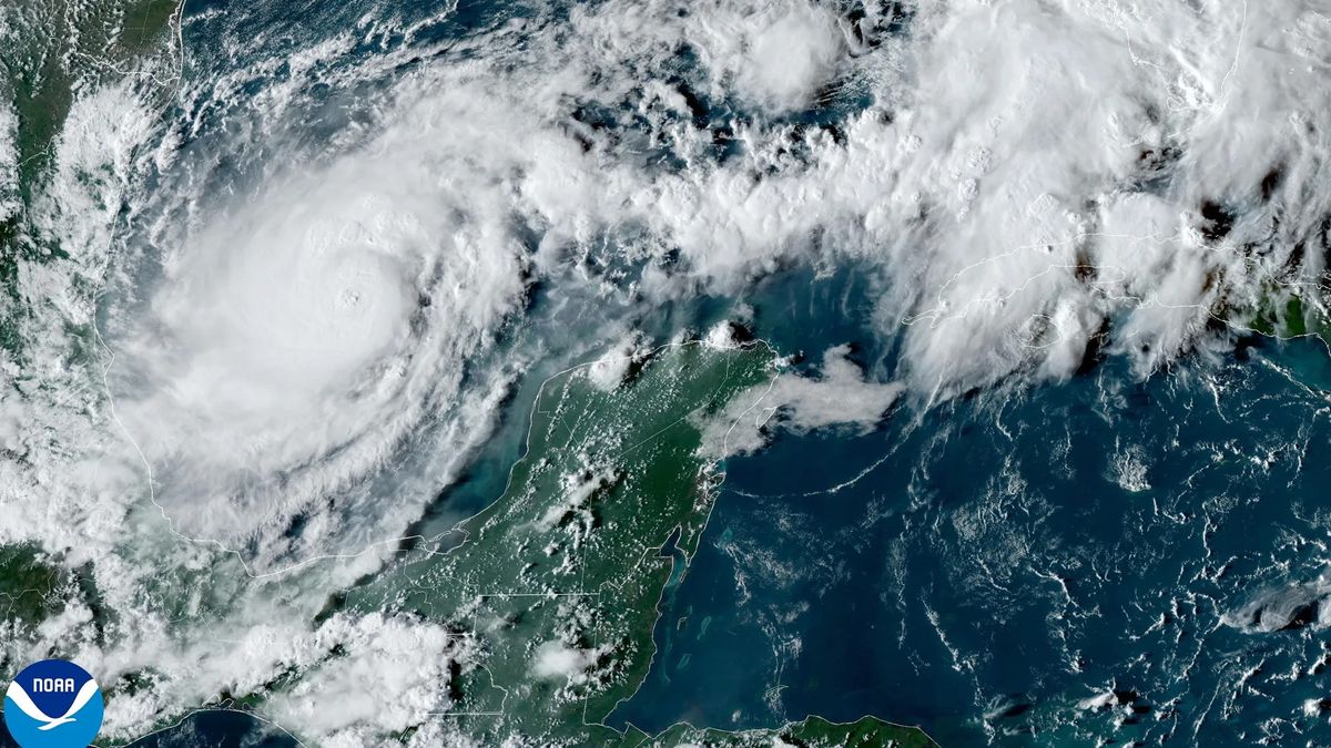
Hurricane Milton, currently churning its way eastward from the western Gulf of Mexico, strengthened from a tropical storm into a Category 1 hurricane on Sunday (Oct. 6) night, according to the National Weather Service. By mid-morning Monday, it had exploded into a Category 4 hurricane with sustained winds of at least 150 miles per hour (241 km/h). As of 2 p.m. EDT, it had swelled into a Category 5 storm with sustained winds near 175 mph (280 km/h) and even higher gusts, according to the National Hurricane Center.
Officials forecast that the hurricane will maintain most of its intensity before it makes landfall in or near the Tampa Bay area on Tuesday night (Oct. 8) or Wednesday morning. Milton’s winds will bring yet another deadly storm surge to Florida’s west coast as the region still reels from Helene.
The appearance of the hurricane has prompted renewed evacuation orders across Florida. Republican Governor Ron DeSantis declared a state of emergency for 35 counties on Saturday, according to a statement from his office.
“I highly encourage you to evacuate,” Kevin Guthrie, the executive director of the Florida Division of Emergency Management, said at a news conference on Sunday night. “We are preparing … for the largest evacuation that we have seen, most likely since 2017, [for] Hurricane Irma.”
Related: We may need a new ‘Category 6’ hurricane level for winds over 192 mph, study suggests
In 2017, 6.8 million people evacuated their homes in advance of Irma, which killed more than 130 people across Florida and the Caribbean, according to the Federal Emergency Management Agency.
When it hits, Milton is likely to be particularly dangerous because it’s landing on a region already devastated from a glancing blow by Helene. Helene was a Category 4 hurricane when it made landfall late on Sept. 26 — but even though Tampa Bay didn’t sustain a direct hit, the area experienced storm surges up to eight feet (2.4 meters) high.
Milton is gaining strength rapidly because of its small pinhole eye, which has a maximum wind radius of 11 miles (18 km), compared to Helene’s 60 miles (97 km). Hurricanes with smaller eyes tend to be more powerful as they dissipate energy slower and spin faster.
“This is the most impactful storm we have faced, much stronger than Hurricane Helene,” St. Petersburg Mayor Ken Welch said at a news conference. “We already will be rebuilding for years because of Hurricane Helene, and that will be exacerbated by the impacts of this storm.”
“Remember, Hurricane Helene was 100 miles [161 km] away from us [in St. Pete], moving in a different direction,” Welch added. “This is a powerful Category 2 or 3 hurricane headed directly for us,” he said at the time. Since then, the storm has grown.
Hurricanes grow from a thin layer of warm ocean water that evaporates and rises to form storm clouds. The warmer the ocean is, the more energy the system gets, accelerating the formation process so that violent storms can rapidly take shape. This is why hurricane season occurs from June to November and why the most powerful storms in the Atlantic usually occur between August and September, when ocean temperatures peak.
Climate change has made extremely active Atlantic hurricane seasons much more likely than they were in the 1980s. Since March 2023, average sea surface temperatures around the world have hit record-shattering highs, giving storms like Milton and Helene an extra boost before they make landfall.
“Milton is the 3rd Atlantic storm to become a major hurricane since September 26 (Helene, Kirk),” Philip Klotzbach, a meteorologist at Colorado State University, wrote on X. “This is the most on record for the Atlantic between September 26 – October 7, breaking the old record of 2 set in 1893, 1941 and 1959.”


