


QUICK FACTS
Where is it? Whitetail Butte, Priest River, Idaho [48.411815594, -116.84501960]
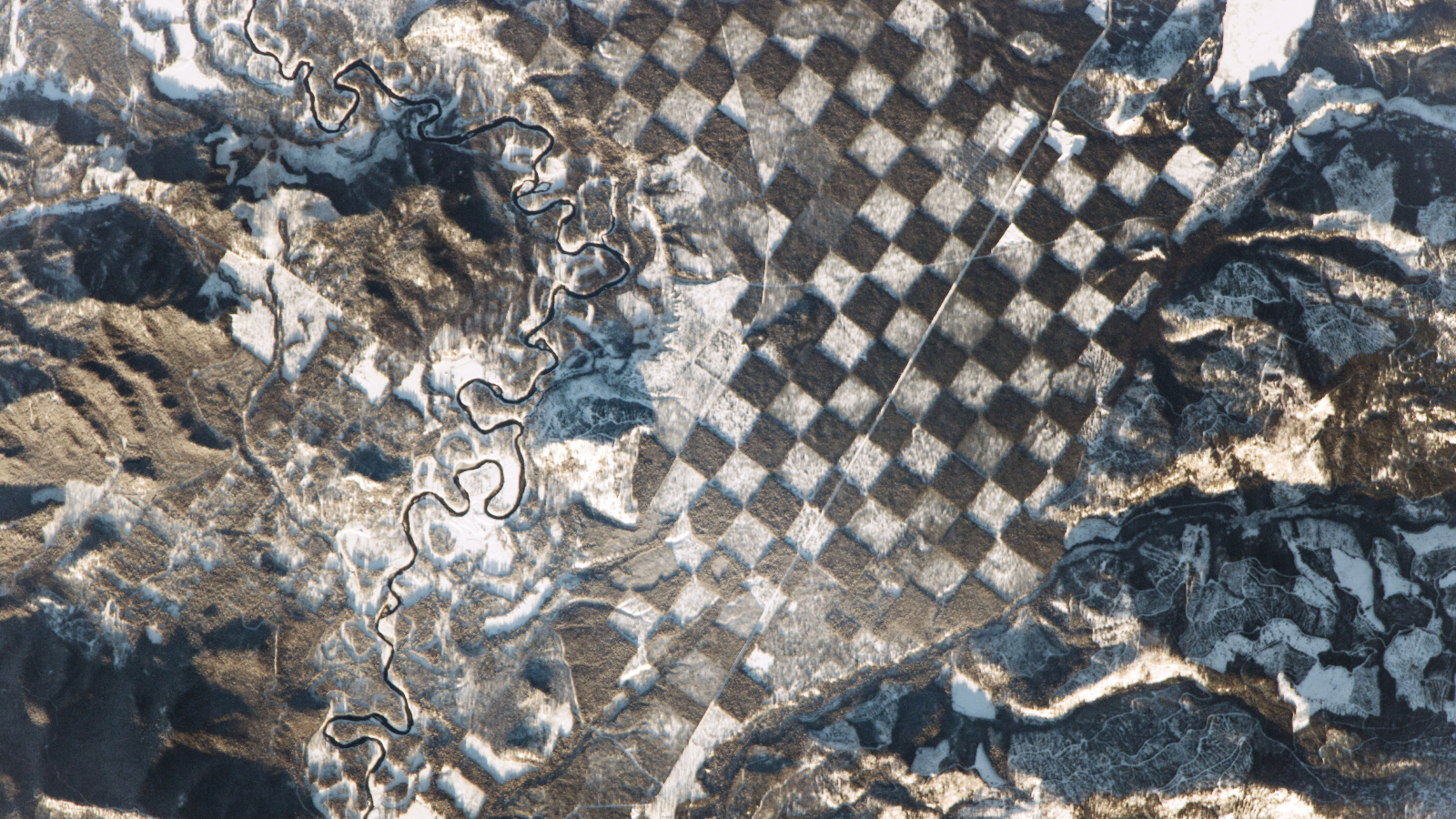
What’s in the photo? A section of forest divided into squares due to a grid-based land management system
Who took the photo? An unnamed astronaut on board the International Space Station
When was it taken? Jan. 4, 2017
This intriguing astronaut photo shows a patch of land in Idaho that looks strikingly like a giant chessboard when viewed from space. The strange pattern comes from an environmental initiative dating back roughly 200 years.
The aerial shot shows a tract of land alongside the Priest River in the mountains of northern Idaho, around 40 miles (65 kilometers) south of the Canadian border. The closest point of interest is Whitetail Butte, a lookout point for forest fires, which is positioned on a large bend in the river (roughly halfway along the waterway in the photo).
The “chessboard” is around 5 miles (8 km) across at its widest point and contains approximately 185 squares, although not all of them are visible in this photo. Each square covers around 1.4 million square feet (130,000 square meters) — about the same size as 24 football fields.
This pattern results from a grid-based forest management initiative set up in the 1800s. Alternating squares have been cleared for their timber, leaving enough trees to sustain the forest ecosystem while new trees grow, according to NASA’s Earth Observatory.
New trees are then planted in the empty squares. When the trees have fully matured, the trees on alternating squares are harvested, and the cycle begins again. This photo was likely taken just a few years after the most recent harvest.
The pattern has been accentuated by snow, which has settled on top of saplings in the “empty” white squares. The checkering is also visible during the summer. However, there is much less distinction between some light and dark squares, which appear as various shades of green.
Related: See all the best images of Earth from space
This photo was taken just before sunset, so some mountainsides glow while others are covered in long shadows due to the low angle of the sun.
The Priest River, which is part of the Columbia River basin, was previously used to transport timber from this region to sawmills in other parts of Idaho and beyond. This was traditionally done by “log driving,” which involved floating rafts of logs on the river’s surface, often with people standing on top and using long poles to redirect the rafts and prevent them from jamming.
However, this practice was halted in the 1990s to allow for more recreational uses of the river.
The logs are now transported by road, and if you look closely, you can see the faint line of a purpose-built trucking road passing diagonally through multiple squares of the checkered forest.


