


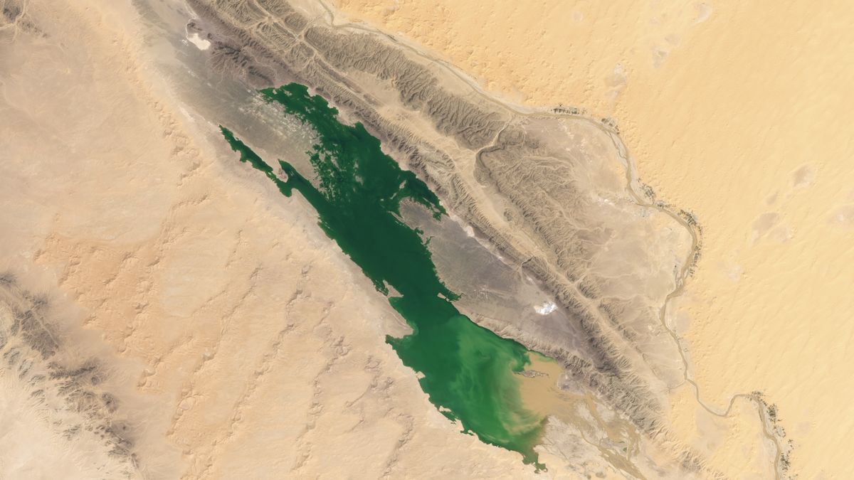

The Sebkha el Melah ephemeral lake in Algeria, seen on Aug. 12 and Sept. 29. (Image credit: NASA Earth Observatory images by Michala Garrison, using Landsat data from the U.S. Geological Survey)
Lakes have appeared in the Sahara after a cyclone brought a deluge of rain to northern Africa that drenched swathes of the largest hot desert on Earth, satellite images show.
An extratropical cyclone hit parts of Morocco, Algeria, Tunisia and Libya on Sept. 7 and 8, dropping around 8 inches (20 centimeters) on the affected areas — equivalent to an entire year’s worth of rainfall in just a few days, according to NASA’s Earth Observatory.
The deluge and runoff filled multiple ephemeral lakes in the Sahara, including the Sebkha el Melah in Algeria and several dotted around the Erg Chebbi — a vast expanse of star dunes in Morocco. NASA’s Moderate Resolution Imaging Spectroradiometer (MODIS) on the Terra satellite also captured several ephemeral lakes appearing across parts of Morocco and Algeria.
The Erg Chebbi lakes filled after rivers from the nearby Atlas Mountains overflowed close to Merzouga, a town near the Algerian border that serves as a gateway to the star dunes. An image captured on Oct. 1 by one of the Copernicus Sentinel-2 satellites shows new lakes dotted around the edges of Erg Chebbi.
NASA’s Landsat 9 satellite captured the images of the newly filled Sebkha el Melah lake in Algeria. Images captured on Aug. 12 and Sept. 29 and shared by Earth Observatory show changes to the landscape, with a green lake appearing in the desert.
Images of Erg Chebbi, with the first showing the region in 2021, the second after the deluge, taken Oct. 1, 2024 (Image credit: Google Earth/European Union, Copernicus Sentinel-2 imagery)
The lake covered 74 square miles (191 square kilometers) and was approximately 7.2 feet (2.2 meters) deep, according to calculations by Moshe Armon, a senior lecturer at the Hebrew University of Jerusalem. Armon used satellite images to establish the extent of the water combined with a 3D map of the lake, according to Earth Observatory.
Since 2000, there have been two times when water levels at Sebkha el Melah were higher than they are now. In 2008, the lake filled after an extratropical cyclone that led to exceptionally heavy rainfall. It took four years for the lake to completely dry up again.
Images showing Algeria and Morocco on Aug. 14 and Oct. 9 (Image credit: MODIS Land Rapid Response Team, NASA GSFC)
The water currently filling Sebkha el Melah will likely remain for some time. “If we don’t get any more rain events, a 2.2-meter depth, like we have now, would take about a year to evaporate completely,” Armon said in the statement.
Understanding how rainfall events like the cyclone in September impact the Sahara help researchers better understand what the desert was like thousands of years ago, when it was green, and how it will change in the future as a result of climate change.
Current projections suggest parts of the Sahara will receive more rainfall, but there are huge uncertainties. “What’s going to happen in the Sahara remains very unclear, but we hope that we’ll eventually develop a better understanding of the Sahara’s future by studying these lake-filling events,” Armon said.


