


QUICK FACTS
Where is it? Heard Island, Indian Ocean [-53.116414344, 73.51793263]
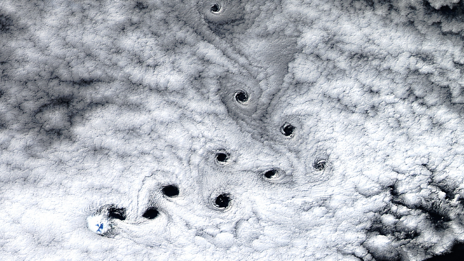
What’s in the photo? An unusual stream of von Kármán vortices trailing off a hidden peak
Which satellite took the photo? Landsat 8
When was it taken? May 3, 2016
This striking satellite photo shows 10 swirling “dark voids” that appeared above an uninhabited volcanic island in the Indian Ocean. The black spots are the result of atmospheric cloud vortices, but are oddly pronounced and significantly contorted compared to most other examples of this phenomenon.
The spinning voids are trailing off Heard Island — an uninhabited Australian territory in the southern Indian Ocean, around 900 miles (1,500 kilometers) north of Antarctica. The cloud-obscured landmass has a surface area of around 142 square miles (368 square kilometers).
On average, the dark spots are around 8 miles (13 km) wide, decreasing slightly in size the further they have traveled, according to NASA’s Earth Observatory. They are initially moving away from the island in a northeasterly direction (left to right).
The spinning holes are the result of a phenomenon known as von Kármán vortices, which occur when a prevailing wind encounters a landmass, disturbing the airflow and creating “a double row of vortices which alternate their direction of rotation,” according to the National Oceanic and Atmospheric Administration. They are named for Theodore von Kármán, a Hungarian-American physicist, who was the first to describe this natural phenomenon.
In this case, the vortices are being created by Mawson Peak, a 9,000-foot-tall (2,700 meters) active volcano sat at the heart of Heard Island.
Related: See all the best images of Earth from space
Normally, von Kármán vortices create long trails of swirling clouds that get caught up in the disrupted air flows. The cloud streams are normally perfectly straight, such as a series of parallel vortex streams that emerged side-by-side off the Atlantic coast of Africa in 2015 (see above).
But in this case, the vortex stream appears to bend almost 90 degrees midway through the stream. This change in direction was most likely caused by a sporadic burst of the intense westerly winds that frequently blow across the area around Heard Island at speeds over 50 mph (80km/h), known as the “Furious Fifties,” according to the Earth Observatory.
In most examples of von Kármán vortices, the resulting cloud trails can be quite wispy, tracing out the subtle variations in the invisible air currents, such as examples observed over Mexico’s Guadalupe Island in 2012 and above Svalbard’s Bear Island in 2023.
However, in this photo, the wispy trails are replaced by a string of concentrated holes, or gaps, within the clouds. This is probably due to exceptionally thick cloud coverage, which can be disrupted only at the heart of each spinning section within the vortex stream.
Mawson Peak is smaller than most of the peaks that regularly produce von Kármán vortices, making it slightly rarer for the cloud swirls to emerge there. However, Heard Island has produced more traditional vortex streams in the past, such as one showing in November 2015.


